Invisible Public Facilities - Public Pipelines
Published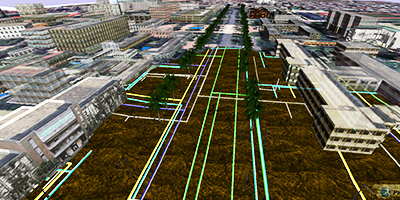
<p>
After the air explosion of underground pipelines in Kaohsiung, the management of pipelines, which is often overlooked by the public, has led to concerns about pipelines underneath roads in daily life. The management of pipelines is very complicated.<br>The Department of Construction, Ministry of the Interior announced the "Public Facility Pipeline Database Standard System for the National Land Information System" in 1987, and completed the compilation of the required public facility pipeline data standards for consultation within the database group to establish a demand response document.
The Department of Construction of the Ministry of the Interior has prepared a standard for public facility pipeline data at the level of "consultation between data supply and demand units" in 2007, and published it for use by public facility pipeline data-related units after examination. Although there are so many rules and regulations, it is necessary to explore the implementation or practicality of the results in terms of measurement, recording, management, etc. by each local unit.
Public facility pipelines include 8 major pipelines, and their data life cycle includes the planning, design, construction, maintenance and operation management of pipeline projects. The 8 major pipelines are complicated, and the previous management method is mainly based on 2D planes, but often due to measurement errors, record errors, and personnel errors, resulting in system errors.
The application of 3D GIS underground pipeline is to allow managers to clearly see what direction the underground pipeline is going, where the valves, water meters and joints are located. It is like taking an X-ray of a person's skeleton to see where a fracture occurs and where a surgical connection is needed. However, various types of pipelines are complicated and managed by different units. Therefore, it is an urgent issue for government agencies to establish a systematic and effective 3D smart city pipeline database and apply it properly.
Pipeline at a Glance 3D Pipeline Applications
The visual 3D pipeline management method can be used to observe the site conditions from multiple angles in 2D and 3D. In addition to presenting the information that can only be presented in the form of data sheets and flat maps, it can also check the correctness of data sources in the most intuitive way, and facilitate regular and irregular pipeline maintenance inspection, replacement and anti-theft work.
PilotGaea proposes a 3D pipeline solution that combines GIS and 3D visual graphics to clearly present pipeline data visually, providing managers with the ability to immediately grasp the accuracy of data sources when managing data, as well as to assist in more supportive decision making through real-time GIS analysis.
Demo: http://youtu.be/R7_nlnz9icc
Applications: http://youtu.be/Ff5kINx8cf0
</p>